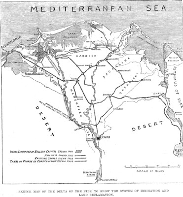
"Egypt is the Gift of the River "—that is, of the Nile. This remark of old Herodotus will again and again be quoted, because it must for ever be true. In Mr. Stanley Lane Poole's useful little book of last year—one of the "Foreign Countries and British Colonies,'' series—the first two chapters give a striking description of the physical features of Upper and Lower Egypt. Were it not for the Nile, all that country would be part of the great African Desert; hard, dry, barren rock, with patches of gravel and sand, here a stony elevation, there a depression, the bed of an occasional torrent, or of a precarious pool. It would be like the Sahara, and not unlike much of the interior of Australia and of South Africa, beyond hope even of pastoral occupation. But down comes the Nile, flowing 3000 miles and more from the Equatorial Lakes and from the Abyssinian mountain, bursting its passage through the Nubian rock-barriers, and thence from Assouan, below the Cataracts, forming a stream greater than that of the Thames at London, often half a mile wide. It runs through a valley of ten miles breadth, between the Libyan and the Arabian hill-ranges, nearly all the way down to Cairo. This Valley of the Nile is the most ancient Egypt, including Thebes and Memphis, with their amazing monuments of all almost pre-Historic rich and powerful civilisation. Below Cairo, the scene changes, as the mighty river, the parent of Egypt, approaching the sea within two hundred miles of its course, divides into several branches, spreading to the north-west and to the north-east, as well as due north. There were formerly seven of these; but only two are still fully open and in constant river-flow—namely, that of Rosetta and that of Damietta; the others have been reduced to canals or long ditches, but serve for the distribution of water.
This extensive tract of lowland is the Delta, so called from the shape of the Greek capital letter D, which is an equilateral triangle. The apex of the triangle is to the south, a few miles below Cairo. Its north-west point stay be found at Alexandra, fourteen miles west of the Rosetta mouth of the Nile. Its north-east point is Damietta, now the most easterly mouth; but, in the ancient time, there were also the Tanitic mouth, near what has been made Port Said, and the Pelusiac, still further east. The Delta, in its present limits, measures about one hundred and sixty miles along each of its three sides. The north side, front Alexandria to Damietta, is not exactly the Mediterrinean seacoast, but an inner shore-line, formed by several lagoons, of mixed salt and fresh water, separated from the sea by long sandbanks, but with a few entrances, and divided from each other by projecting tracts of lowland.
For the remainder of this three column report see: The Illustrated London News, No.2255—Vol. LXXXI, Saturday, July 22, 1882, p.94